Nov 162020
 

Late released agenda items for Tuesday night’s council meeting include proposals from staff to make parking free and unlimited in the City to “encourage visitation”.  You can make a submission via https://www.melbourne.vic.gov.au/about-council/committees-meetings/meeting-archive/pages/Future-Melbourne-Committee-17-November-2020.aspx.  Submissions must be made before 10:00AM Tuesday 17th November 2020. Agenda item 6.3, recommendation 16.3.

Below are some points you could include.

  1. The policy will not work. Experience during lockdown showed that free parking = no parking. Parking is occupied by workers who arrive before customers.  In the case of evening and weekend activation of the CBD, hospitality workers will arrive before customers and take all the free parking.


    During working hours, extended or free parking is occupied by tradies who would normally park off-street or use public transport. Parking available for deliveries and drop-offs is actually reduced by free and extended on-street parking.

  2. Outdoor dining is central to recovery of restaurants. The City is converting parking space to dining space. How does it work to make the fewer remaining spaces unlimited and therefore unavailable? We need to be removing cars and parking to take advantage of the public open space provided by roads and streets. There is a reason why Melbourne’s laneways are so popular – they are car free.
  3. Encouraging more cars to enter the CBD does not encourage visitation. The dominant modes and the modes preferred under the City’s Transport Strategy are PT, walking and cycling. PT creates walking trips (last mile). Walking and cycling are discouraged, made less convenient and more dangerous by having more cars, so the policy will discourage the most common modes of access.
  4. Encouraging visitation to support businesses should aim at customers who will spend money. $10 flat fee from commercial car parks is small compared to the amount spent by CBD evening and weekend visitors and does not act as a disincentive.
  5. Car park operators have lost most of their revenue for the last 6 months, the free parking proposal will further reduce their revenue. There is ample space provided by off-street commercial parking providers, usually at a flat fee (unlimited time) during evenings and weekends, so on-street parking is a waste of scarce and valuable space.
  6. The officer’s agenda item is disingenuous regarding consultation on the City’s Transport Strategy. That consultation did not support encouraging more car trips into the City and the Strategy aims to reduce car travel, not increase it.
 Posted by at 12:23 pm
Oct 102020
 

At these elections there are two tickets with an outstanding track record of supporting and achieving outcomes for bikes.  These are The Greens and Team Sally Capp. Here we present what we know about the candidates in relation to getting more people riding bikes.

Cr Leppert (Greens) has worked tirelessly during his eight years on council for better outcomes for bikes and is the outstanding councillor candidate. The outcome of his hard work and advocacy put Melbourne in a position to move quickly during the pandemic, based on the plans and policies established in years previously.

Sally Capp took office as Lord Mayor in a by-election in 2018, and has used her leadership position to change the council’s direction on bicycles. In her first week in office she was photographed by the Herald Sun riding to a meeting in the CBD, a statement more powerful than any words. This year during the pandemic she announced 40km of protected bike lanes to be built in the current financial year. Her only misstep has been an election promise of free parking on weekends to encourage visitation to the City. This puts at risk the street activation needed to locate dining and socialising outdoors, which is key to saving our hospitality businesses during the pandemic, also key to traffic calming the little streets and laneways. We predict free parking will be 100% occupied by workers, who arrive earlier than the diners and it will actually decrease parking available to visitors.

Morgan-Watts Team

Most councillor debate occurs behind closed doors and most motions are passed unanimously. This makes it hard to assess sitting councillors on their voting record.  A rare exception was Agenda Item 7.1 on Future Melbourne Committee 6th August 2013 when Cr Foster moved, and Cr Jackie Watts seconded a motion to defer any further works on the Princes Bridge/St Kilda Rd Bike Lanes (meeting minutes can be viewed at http://www.melbourne.vic.gov.au/about-council/committees-meetings/meeting-archive/meetingagendaitemattachments/621/aug13%20fmc1%20confirmed%20minutes.pdf). This came after extensive consultation with stakeholders and the community, permission from VicRoads to remove two car-traffic lanes on the bridge, and only a few days before the work was due to be carried out.  The key request in this motion was “an assessment of community concerns relating to congestion and public safety and any proposed remedy by management to address such matters.” (our emphasis). The motion was lost and the inbound bike lane went ahead, with Yarra Trams holding up the outbound lane owing to their plans to widen the outbound tram platform – the outbound bike lane on Princes Bridge later went ahead when Metro Tunnel closed a lane in Flinders St and Yarra Trams widened their platform.

Cr Watts was kind enough to provide a response:
“Rest assured my pro-cycling stance has not shifted. I have consistently voted in favour alf[sic] all pro cycling Motions.
The Motion you cite was not opposing cycling – but reflecting community anxiety expressed to me. “

Published policies do not mention bikes but encouraging driving to the free tram boundary; subsidise parking; retain car parking on planned open space adjacent to Vic Market (current plans underway will provide more parking than the current car park). https://jackiewatts.com.au/morgan-watts-policies/

Other candidates

We searched candidate statements for mention of bicycles and found these candidates in support:

Animal Justice Party “more… cycling routes…”

Innovate Melbourne – Startup The City “we like to ride our bikes…”

In support of cars and parking we found:

Back to Business “… Council’s war on cars”

Team Arron Wood Quoted in The Age Oct 15, 2019 “… warned against excessive investment in bike lanes. “We’ve got to be mindful and realistic about some of these modal shifts and just how much they can deliver,” he said.”

Bring Back Melbourne “… on-street parking credit”


 Posted by at 11:09 pm
Jun 012020
 

The Amy Gillett Foundation released its big coronavirus related campaign to get more bike lanes built in Australia yesterday. A lot of businesses signed on to the campaign, which shows just how many hard-working people support the foundation and its mission. But the AGF is starved of cash, undemocratic, and is now duplicating others’ work. It’s time for the foundation to close down and for its members to work with the rest of the cycling community towards its laudable goals.

The AGF was started in response to the tragic death of track cyclist Amy Gillett in Germany in 2005. The organisation has a scholarship designed to support competitive female cyclists and also a program of research and advocacy to improve bicycle safety on our roads.

One of the AGF’s strengths has always been its ability to use connections with the sports cycling world to garner support from corporate and conservative sections of our community. In a space dominated by left wing organisations, this was their unique advantage. They spearheaded the “A Metre Matters” campaign – which led to one metre passing laws in almost every state. These laws were often introduced by conservative governments, no doubt with the help of Liberal party heavyweight and ex-AGF board member Mark Texter.

There has always been a diversity of groups supporting cycling advocacy in Australia. Each group has its own perspective, and they can work together towards a common goal. But diversity only succeeds if these groups can work together.

With the “A meter matters” campaign largely complete, the AGF is struggling to figure out where it fits in with other organisations. Their latest advocacy campaign focuses on the right topics, but shows that it can’t work well with others.

The campaign is a great idea – to get businesses to support temporary bicycle infrastructure in our cities. But they have largely duplicated the work already done by Cycling Works Australia and Bicycle Network. Cycling Works have put a massive amount of work into their business campaign, and other advocacy groups like Bicycle NSW and We Ride Australia respected and supported that work. Bicycle Network already has a fully-fledged campaign lobbying specifically for temporary lanes for coronavirus. The AGF has duplicated these efforts which makes advocacy look fragmented and makes it harder to get things done.

The AGF also differentiated itself in the past with its focus on research. But there are limits to how much research can help. The benefits of cycling have been clearly established in hundreds of research papers. We do not need more research to know how to build safe bike lanes. The AGF’s latest project “Bike Spot 2.0” is a duplication of a very similar project that was completed only a few years ago. Repeating these projects over and over again is a good way to get grant funding, but the link to actual safety improvements is tenuous. The more organisations such as the AGF rely on government funding of this type to cover costs, the greater their desire will be to please governments instead of achieving real change.

Because The AGF is not member based, it is less democratic than other cycling advocacy organisations and therefore does not respond well to changes in community views. For instance, the AGF were involved in negotiations with the NSW government that led to some of the highest cycling fines anywhere in the world. The AGF maintains its defence of mandatory helmet laws despite their association with discriminatory police practices towards children in low socioeconomic suburbs and their net health cost to the community. And they continue with their “share the road” campaign despite international evidence that this strategy is ineffective at changing driver behaviour.

The AGF lost $180,000 last financial year, on total revenues that were down 15%. Annual reports for earlier years are not available, because the AGF’s website sends users to dead links and errors. The financial crunch has not just hampered their ability to run a functioning website, but it has also led The AGF to make decisions that put their independence into question, such as moving from their St Kilda Road office to desks at the ARRB group – a largely government funded organisation.

Cycling advocacy is becoming a crowded field, and the damage done by having too many organisations is growing. Profits from events like the “Amy Grand Fondo” help to fund cycling organisations, and they now operate in a far more competitive space than 15 years ago where multiple charities and fun runs compete for attendance. The coronavirus crisis is only going to worsen the crunch for mass event rides, making it harder for them to subsidise advocacy. There are benefits to scale, and it no longer makes sense for Bicycle Network and the AGF to operate in this market.

There is no reason for the AGF to continue to exist. The research functions would be more respected if branded by universities rather than lobbying organisations. The rides would be much more efficient if run by Bicycle Network. Federal cycling advocacy can be run by We Ride, and state advocacy would be more unified and co-ordinated if run by the various democratic organisations such as Bicycle Network and Bicycle NSW. The Amy Gillett scholarship can be awarded by Cycling Australia.

The AGF’s employees, volunteers and supporters should continue their hard work to support cycling safety. But they will be much more effective at achieving change if the foundation ends and they work together with the rest of the cycling community.

 Posted by at 8:05 pm
May 062020
 

There’s been a lot of talk on Facebook and Twitter about a new protected intersection currently being installed on Albert Street in East Melbourne. The protected intersection was funded through the $100m TAC Safer Cycling and Pedestrian fund, promised by the Andrews government before the 2014 election. Many of the projects on the list have been delayed significantly, and there is concern some of the money has been diverted to non-cycling related projects, so it’s fantastic to see something finally being built!

The bike lanes are not finished yet. There’s green paint to go in, and the signals and lighting are not finished. But you can ride it now.

Some on social media are concerned that this design deviates from the classic “Dutch” intersection design, and NACTO guidelines. They worry that it could be more dangerous than what was there before, particularly on the downhill approach along Albert Street heading east. One commentator on a cycling Facebook group went as far as to say:

(This is a) Hazardous design & taking away bicycle riders rights to give left turning cars priority. As an engineer who has built bikeways for over a decade and has 38yrs of commuter cycling I say that design is hazardous & probably a disgusting attempt to keep bicycle riders subservient to motorists.

These are serious charges. Concerns about this new design fall into three distinct categories:

  1. The ‘banana’ humps are difficult to see, and cyclists might run into them.
  2. The tight angle of the intersection forces cyclists to slow down too much, and is generally awkward.
  3. By forcing cyclists to deviate left, the intersection gives left turning vehicles priority over cyclists.

While these concerns are genuine and earnest, we think that on balance they are mistaken. We think it’s a good design which Melbourne cyclists can be proud of.

We’ll go through each of these concerns individually. But first it is worth dispelling one myth. We have met with some of the people who designed the intersection, and can confirm that they are not part of a conspiracy to make bikes subservient to cars. The designers are mostly cyclists, who are earnestly trying to improve the safety and comfort of cyclists in Melbourne. Unlike most projects in Melbourne where cyclists are simply an afterthought, this project was focused from start to finish on improving bike safety. The project involved the removal of a peak hour vehicle turn lane at a major Melbourne intersection – something that would have bee simply unheard of only a few years ago.

Why make an intersection protected?

The unavoidable problem with all intersections is that some vehicles want to turn left, and some cyclists want to travel straight ahead. Without banning left turns or separating with signals, no grade intersection can completely remove this problem. It can only be managed. Protected intersections improve safety in two ways:

  1. Vehicles have a slow speed on the approach to the left turn conflict point, and
  2. Cars and bikes face each other at a 90 degree angle at the conflict point.

Because everybody is going slowly in a protected intersection, and everyone is facing each other, the risk of a crash is greatly decreased.

So how does Albert Street match up? For cars, the width of the entrance into Lansdowne Street has been decreased from 10m wide to 6m. That will make the left turn into Landsdowne street much tighter for cars, forcing them to slow down.

Once cars have slowed down to turn left, they will be facing cyclists at a 90 degree angle. This will mean that cyclists and car drivers can look each other in the eye.

Based on these criteria, the Albert street protected intersection is a big success.

The intersection will slow cyclists down – and that’s a good thing

The downhill section of Albert Street is a death trap. Cyclists travelling at 40km/h go head to head with left turning cars every day. Experienced cyclists might feel that they can manage this risk well, but conditions such as this are unlikely to encourage more people onto their bikes.

The Dutch have the advantage of relatively flat roads which help to keep average cyclist speed between 13 and 20 km/h.

There is no safe way to design this intersection that does not involve all vehicles (including cyclists) slowing down.

The good news is that while you will be going slower through this intersection, the overall length of your trip will not be longer. City of Melbourne have introduced a ‘green wave’ on Albert Street – so the average cyclist will get to Richmond faster than before.

And while this intersection design forces you to slow down, some of the complaints about overestimate just how tight it is. The intersection has only just been resurfaced, and so you can see that much of the “kerb” is completely flat with the road:

It is actually quite comfortable for cyclists to round the intersection at a moderate speed without aggressive turns. Far from being a slalom, most people take the intersection with only a single turn out and a single turn back in.

Why did they change the design from Dutch/NACTO standards?

There’s a lot of frustration about VicRoads ‘reinventing the wheel’ here and not just using Dutch guidelines. But the changes were made for good reasons.

Traditionally with these intersections, the cycle lane stays more or less straight and the ‘turn’ space for cars is inside the intersection.

Figure: Because the protection in The Netherlands is in the intersection, bikes do not have to deviate from their path.

Many intersections in The Netherlands do force cyclists to turn away from their desire lines, but the curves tend to be much subtler than what we see on Albert Street, particularly on the North West corner where space is tightest.

Figure: The bike lane here in The Netherlands deviates away from the intersection. It would be much easier to cycle through Melbourne’s protected intersection at speed than this one. 

To make a protected intersection, you need to have enough space so that the car has turned left by the time they cross the cyclist’s path. We could have pushed this space in to the centre of the road, which would have meant cyclists would have deviated less. To find this space we could have narrowed the median of Albert Street, but that would have created heritage concerns and involved destroying a tree. We could have reduced the number of traffic lanes, but this project has already taken a turn lane away. We could have narrowed the footpath (something they’re not afraid of doing in the Netherlands), but that’s undesirable for lots of reasons.

It would have been a better result had the department sacrificed two traffic lanes for the project, but given any safe design will slow cyclists down anyway, the damage done by only removing one traffic lane is not extreme.

Much has been made of the protected humps being the ‘wrong shape’. In the Netherlands they look like almonds, whereas we have ended up with bananas. But the difference between the two should not be overstated. This design only used bananas to enable more storage space in the intersection for bicycles turning. In fact, when you ignore the mounted portion of the banana it looks very much like an Almond.

Are the humps dangerous?

Concerns that the banana humps are dangerous are legitimate. It’s more than possible that a cyclist heading down the hill at a high speed could fail to see the humps and crash into them. There a few reasons to be less concerned about this possibility though:

  1. Faster cyclists also tend to be more regular cyclists, so they will get used to the new design quickly,
  2. This is a popular route, so cyclists will be able to follow the person ahead of them during peak times,
  3. The downhill section faces east, so there are no issues with glare at sunset during the PM peak hour, and
  4. The project includes new street lighting – which is yet to be installed.

We think that the banana humps should be painted a different colour and/or given a reflective treatment to ensure that cyclists can see them at night. But let’s wait and see what it looks like when the street lighting is installed first.

Will cars give way to bikes at this intersection?

Perhaps the most controversial question is who will give way to who at this intersection.

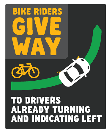
At regular intersections, bikes must give way to cars which are indicating and already turning left. But there is no clear definition of when a car begins it’s left turn, which made the situation very confusing.

The installation of bike signals means that legally, drivers must now give way to bikes.

We don’t think the legal question is too important though – drivers will take their cue from the surroundings.

One of the challenges in Australia with protected intersections is that we don’t have the design language to tell drivers who has right of way at these conflict points. The Netherlands benefits from a ‘sharks teeth’ road marking which makes it clear who gives way to whom.

Figure: “sharks teeth” triangles in The Netherlands tell drivers to give way.

Managing the conflict here in Australia without sharks teeth is tough. Even if we started including them in new roads, it would take years for drivers to learn what they mean.

One way around this on Moray Street in South Melbourne was to build in a speed hump. That could have been a possibility here, but it would have added complexity to an already novel design. It also would have slowed cyclists more.

Because this intersection is in a much tighter space than some seen in the Netherlands, there is no room for a zebra crossing across the bike lane. That means that there must be two stop lines at each leg of the intersection (one for right turning bikes, and one for straight through). It’s possible that drivers might see this second stop line and think bikes should give way.

However, there are good reason to think that drivers will give way to pedestrians. The protected intersection design places cyclists in a similar position as pedestrians, and drivers are used to the idea that they should give way to people at this location in an intersection. This intersection also slows drivers with a very sharp turn, which increases the chance they will give way. And chance that drivers will think cyclists are turning left is not high, since (as seen below) cyclists do not change their angle very much on their way into the intersection.

When we visited the site today, we found that every car gave way to bikes, even when they entered the intersection before the bikes.

With green paint across the intersection it will make it even more clear that bikes have priority here. Bikes will also have a head start at the intersection, meaning that they will be able to get ahead of drivers before they begin to turn left.

It’s impossible to know what will happen in reality, especially over the next six months as everybody gets used to this new intersection design. So let’s wait for the green paint and then see.

Our suggestions for this intersection

There are other issues this intersection that we have not seen mentioned on social media. We are concerned that the pedestrian desire lines are interrupted, which might lead some pedestrians to walk in the bike lane for part of the intersection. We didn’t witness this at the site visit today, but it’s something to watch for.

And there have been a few cat eyes placed across the desire line of cyclists. These could be easily moved to a spot where they won’t be run over by cyclists in the wet.

Figure: A red cat-eye has been placed in an awkward position.

The bicycle lanterns are a bit far back from the intersection. This could be fixed by rotating them to the other side of the pole.

Figure: bicycle lanterns are not easily visible from the bicycle stop line.

When the lanterns go on we’ll be interested to see green times. Some crossings like this turn red well before the main intersection, and if that happens here it will cause problems as many cyclists get confused about which signal they should abide by.

Thinking more broadly, Lansdowne probably wasn’t the best intersection for this. There are far more left turn conflicts at Gisborne Street. But doing the first one on Gisborne would have involved dealing with Yarra Trams and the Eye and Ear renovations, and so it’s understanding that they decided to pick off an easier target first.

There is also the issue of cost. If pilot projects set a benchmark for a protected intersection that costs millions of dollars, it will be much more difficult to get many of them built across the city. We need to think about how to achieve the same outcomes with far less infrastructure.

Conclusion

Critics of the design raise some good points, but we think it’s premature to draw negative conclusions. When Albert Street’s protected lanes were originally put in they were criticised for ‘hemming in’ vehicular cyclists. It took years for drivers to get used to the new treatment and realise they were not supposed to park in the bike lane. But bicycle numbers on the route increased as those who were too scared to get on a bike were drawn to the extra feeling of protection they provided.

Since then, Albert street has provided a base off which Melbourne was able to build many more protected lanes – with improvements being made to the designs each time.

We think that this treatment will spur a similar wave of improvements to infrastructure that will increase cycling in Melbourne, as more nervous cyclists get on the road.

Before casting judgement, we believe people should wait for this treatment to be finished, the line markings to go in, the lights to be turned on, and for drivers to get used to the design. Then we can begin to have a discussion about what improvements need to be made and how we might do a better job next time.

 Posted by at 9:33 pm
May 022019
 

Belated upate 27/11/2019. On May 19th 2019, Cr Leppert moved “That the Future Melbourne Committee notes the outcome of the study and recommends that Council endorses installation of continuous protected full time bicycle lanes in Exhibition Street in its adoption of the 2019-20 budget.” In priniple there should be no unprotected sections, and the City’s current policy is to run protection up to the stop line, no more skinny lanes at the intersection. The project requires no further Council approval.

The new lanes are now in design and we expect them to be built during 2020.  Thanks to everyone who made a submission to Council. Over one hundred submissions were received, which helps to fortify Council in their determination to improve conditions for active transport in the City.


Council will consider recommendations for building protected bike lanes along Exhibition St on Tuesday 7th May 2019.

Please make a submission in support via https://comdigital.wufoo.com/forms/rly4bj60tdagsg/
Agenda Item title: Exhibition Street Bicycles Lanes
Meeting date: 7/5/2019
Future Melbourne Committee.

Or by email to com.meetings@melbourne.vic.gov.au

Print copies of our leaflet to leave on bikes in your work bike cage: https://bikemelbourne.org/wp-content/bikemelbourne.org/uploads/2019/05/exhibirtion_A4.pdf.

Key deadlines:

2PM Friday, Recommendation published on Council website at https://www.melbourne.vic.gov.au/Pages/meetings-finder.aspx?type=22&month=05&year=2019&attach=True

Now published at https://www.melbourne.vic.gov.au/about-council/committees-meetings/meeting-archive/MeetingAgendaItemAttachments/856/15290/AGENDA%20ITEM%206.5.pdf

12PM Monday, submissions made after this won’t be included in Councillor Briefing

10AM Tuesday, final deadline for submissions.

You can also address the committee meeting, indicate this when you make your submission and your name will be called on the night. If you have experiences on Exhibition St please come and tell your story to the councillors. Your submission can optionally include a powerpoint which will be displayed when you are talking.

From the report:

Existing typical Exhibition Street cross section

Proposed typical mid-block plan

 Posted by at 12:29 pm
Jan 062019
 

Melbourne BUG’s plan to let bikes travel both ways

There are too many cars using Flinders Lane. The City of Melbourne’s pedestrian and transport plans both recommend the section between Swanston and Elizabeth should be for people, not cars. Yet most cars using Flinders Lane simply don’t need to be there. They could use Flinders Street or Collins Street instead.

The City of Melbourne has put a lot of effort into getting commuters into Melbourne’s CBD by bike but there is no way to move around once we are there. Cars and vans can use Collins and Flinders but for bikes there is no safe route on the south side of the CBD. People using bicycles to access Melbourne City Library, the CAE, restaurants and office blocks all have to brave Flinders Street or Collins Street to get where they are going. Both these streets see many crashes, and many more Melbournians are discouraged from riding altogether by the danger of these roads.

Metro Tunnel closed Flinders lane to through traffic in February of 2018, only allowing local deliveries and vehicles that need to access car parks. Five Melbourne BUG volunteers counted traffic during this time and we found that very few vehicles need to use Flinders Lane.

Traffic that needs to access Flinders Lane Degraves Block Hosier Block
Commercial Private Commercial Private Other*
8 a.m. 24 10 11 9 82
9 a.m. 21 21 23 10 57
10 a.m. 17 17 31 7 24
11 a.m. 16 17 19 6 18
12 p.m. 16 9 17 4 14
1 p.m. 17 12 22 3 14
2 p.m. 13 7 15 8 18
3 p.m. 8 8 3 1 0
4 p.m. 5 6      
Total 128 107 144 49 236

*Other is traffic entering the Wilson car park and the Westin Hotel that can exit straight onto Flinders Street and Collins Street without needing to cross Swanston St nor re-enter Flinders Lane.

If the number of vehicles on Flinders Lane were reduced then cyclists could travel both ways. If cyclists could travel both east and west on Flinders lane it would be a low speed local route to get people the last mile to their destination in the CBD.

The route will also act as a ‘connector’ – allowing:

  • Elizabeth and William Street cyclists to access Swanston,
  • Swanston Street cyclists to access Exhibition, and
  • Exhibition street cyclists to access Spring.

Calming Flinders lane won’t just benefit cyclists. By reducing the number and speed of vehicles these changes will make the street safer and more enjoyable for pedestrians too. As less traffic uses the street there will be further opportunities to remove parking to widen the pedestrian area – desperately needed on Flinders lane’s narrow footpaths.

For pedestrians and bicycle safety and comfort we need to limit the number of vehicles on Flinders Lane. To do this we must block through traffic so that each vehicle can only use Flinders lane for one block before turning back into Flinders Street or Collins Street.

Traffic could be limited with turn bans, raised concrete medians in the middle of streets like Russell or by reversing the direction of travel in some sections.

We’ve presented a few options for how this could happen, but there are many more that would work just as well. Each block needs to be looked at holistically after discussion with all the relevant stakeholders.

Some changes we’ve suggested could even provide the opportunity to increase open space on Elizabeth street by making some traffic lanes redundant. Whichever traffic calming methods are chosen, the goal is to prevent rat runs and return the street to the people.

FAQ

Why do cyclists need to travel both ways?

  • There is no safe cycle route on the south of the CBD
  •  Collins Street has a high crash rate.
  • Flinders Street was Melbourne BUG’s preferred south CBD route, but recent tree plantings and tram stops have made this more difficult. The little streets are the only option left.
  • Birrarung Marr is often blocked by festivals and doesn’t provide any local access within the CBD.

Letting bikes go both ways would provide crucial local access for CBD residents and well as the many students and City of Melbourne library users who need to access Flinders Lane.

Many cyclists are already going up Flinders lane to Swanston Street because it is the only option. Our plan would formalise what already exists.

Does this have to be expensive?

Melbourne BUG does not recommend any expensive civil works. Letting bikes travel both ways could be as easy as installing traffic lights for cyclists going in the other direction, coupled with lane markings.

There are ways our treatment could be improved with some civil works. These would be at some cost though – and we think that the first priority should be to get the changes in.

Isn’t Flinders Lane too narrow to let bikes travel both ways ways?

No. Bikes travel both ways commonly on narrow streets in the UK, France, Germany and Belgium. Belgium’s guidelines require a road width of 3m – much narrower than Flinders Lane. Even the most conservative cycling countries accept contra-flow lanes on roads Flinders’ lane width.

One study shows that these lanes actually reduce crash risk by forcing vehicles to travel slower. Another study comparing very narrow contra-flow lanes to wider streets found no difference in crash risk.

All vehicles are going slow and are able to make good eye contact so they can pass each other safely. When the occasional large vehicles approaches cyclists usually get off their bike to allow the truck to pass. This would not be necessary though for the large number of delivery vans who could safely pass bicycles on Flinders Lane.

Will this be dangerous for pedestrians?

This route will work for cyclists as a local route. Most cyclists will only use it for a block or two to get onto a bigger road. Importantly, cyclists travelling the ‘wrong way’ will be going uphill and therefore will be travelling slower.

Fast moving cyclists will get frustrated by the slow traffic light sequences on Flinders Lane and Little Collins Street and will likely continue to use Flinders Street and Collins Street.

Has this been done before in Australia?

Contra-flow Lanes have already been implemented in South Australia on very narrow roads. Adelaide Council has been letting bikes travel both ways on streets Flinders Lane’s width for years. A terrific paper by an Adelaide researcher on this topic is attached.

There are local examples of narrow contra-flow lanes all throughout Melbourne with Yarra and Moreland leading the way. One great example being Truscott Street in Brunswick. These lanes have worked for years without any community backlash or safety problems.

What about parking?

Parking on one side of Flinders Lane could be retained under our plan. Removing some 1-hour parking and converting it to loading zones or 5 minute parking would help to give more space to pedestrians and reduce traffic particularly in the evenings, but it’s not absolutely necessary.

The area between Spring and Exhibition has 6 parks on the north side of the street. These would need to be removed.

Isn’t there too much traffic on Flinders Lane to make this work?

Yes.
City of Melbourne’s transport and Cycling plans both recommend that Flinders Lane between Elizabeth and Swanston should be a place for people, not cars. And yet far too many cars use it everyday.


Figure 1. City of Melbourne’s walking plan

South Australian experience and international guidelines state that there must be less than 1,000 vehicles per day on a narrow road with a contra-flow bicycle lane. To achieve that number you can only allow local access for motor vehicles accessing car parks or deliveries.

Flinders lane is currently flooded with through traffic trying to use this street as a rat run. Google Maps will often suggest drivers take Flinders Lane to get from Albert Street to Spencer Street. If traffic calming is used to stop rat running very few cars need to use each block.

How many vehicles need to use Flinders Lane?

In February of 2018 Melbourne Metro closed Flinders lane to through traffic, allowing only pick ups, deliveries and people who needed to use local car parks. We did a traffic survey during the closure. Only cars accessing car parking on or off the street could enter. Loading and resident parking were allowed but not rat running.

We found that only 244 cars drove on the Degraves block of Flinders Lane over a 9 hour period on a weekday. That’s one car every 2 minutes. The “Hosier” block had one car every minute using the road, but half of this traffic was accessing the Wilson car park near Swanston Street or the Windsor hotel. All of this traffic
can exit via Flinders or Collins Streets. To reduce traffic sufficiently, the current exit from the Wilson car park onto Flinders Lane must be closed, so that cars exit via the exit ramp this car park has on Flinders Street.

As a comparison, Truscott Street in Brunswick has a similar width to Flinders Lane and allows bikes to go both ways with an average of 1 vehicle every minute.

If contraflow works on busier streets in Melbourne it can work on Flinders Lane.


Figure 2. Truscott St Brunswick vs Flinders Lane.

If cars have to turn into Swanston Street won’t that slow bike traffic on Swanston?

One disadvantage of option A is that all traffic from the Hosier and Degraves blocks of Flinders Lane will exit onto Swanston Street. If this is a big concern to council or Yarra Trams then Option B could be chosen. But there are two things to note:

  1. Victoria Police have moved from Flinders Lane (2019). This means there will be no more parked police cars on Swanston Street and therefore a lot more space for bicycles and vehicles to share.
  2. 60% of the cars that would exit via Swanston Street are commercial. If loading was banned between 4:30 and 6:30pm (not a high demand time for deliveries in any case), then the number of vehicles during the afternoon cycling peak could be reduced to one in every three minutes or less.

The footpath outside Young & Jacksons is very crowded. We propose widening the footpath by eliminating parking (mainly used by police), leaving space for a bike lane and no motor traffic. As well as easing pedestrian congestion, this will be a vast improvement for bikes compared to the current squeeze between trams and parked vehicles.

Going in the other direction, loading zones could be provided with a peak hour clearway, an improvement on the current 24 hour police parking there.

What about local traffic?

There are some cars that need to use each block of Flinders Lane – but not many. Our plan maintains full access for deliveries, with no reduction in car parking necessary on most blocks.

Could we have a trial first?

There’s no reason that the traffic calming measures could not be trialled first. Temporary barriers could be inserted where we recommend road blockages coupled with new signs.

After a few months, if traffic has reduced as we predict then bicycles lights can be installed to let bicycles go both ways.

Above: counter-flow traffic lights for bicycles in Tokyo (translation: bicycle specific use)

Why not Little Collins?

We think this could work on all the little streets. International experience suggests that the more streets bikes can go one way on, the less confusion there is for motorists and pedestrians upon seeing a bike going the other way.

Flinders Lane should be first because it is closer to the south side of the CBD, and it is already more popular with cyclists – particularly in the Degraves block. Our research has found more on street bikes parked on Flinders Lane than Little Collins.

Riderlog data is not scientific but the most recently data publicly released as part of City of Melbourne’s transport plan shows that Flinders Lane is more popular than Little Collins for bikes.

Importantly, Flinders Lane provides a ‘last chance’ for Elizabeth Street cyclists to get onto Swanston Street and Princes bridge to exit the city.


Figure 3. Riderlog cycling data from City of Melbourne’s Transport plan.

Is there an opportunity for more open space on Elizabeth Street?

Yes. Depending on where you send traffic there are lots of different options that could free up open space on Elizabeth Street. We’ve presented three ideas below, but the options are endless.


Figure 4. Elizabeth St Options.


 Posted by at 8:02 pm
Oct 082018
 

The glossy documents claim that “Fishermans Bend [will be] an exceptional place to cycle”. However the proposed network relies on eight new bridges which are unfunded.  See Fishermens Bend Framework (PDF). These bridges will also have uphill grades to climb.

On road cycle lanes are not physically separated from motor traffic which will deter most people from using a bicycle. For example Lorimer St is listed as an “existing on-road cycling path.” As an example of the level of service for bicycles it is poor and only a few percent of the population will choose to cycle at this level of provision. Segregation on Lorimer Street was proposed by Melbourne BUG but has been rejected.

Nothing is proposed to prevent rat-running on the street grid.

As usual with Government “strategies” the hype is never matched by action, we expect Fishermens Bend to be no exception. Today’s (8/10/2018) announcement from Richard Wynne, minister for planning, comes days after his government deleted the protected bike lane promised for the massive expansion of the Swan St/Hoddle St intersection, in his electorate.


 Posted by at 1:26 pm